

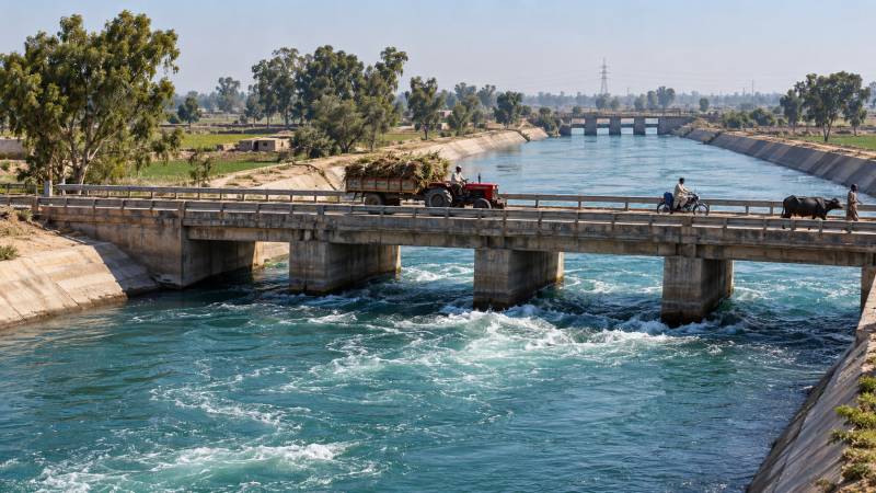
There is something extraordinary about an ordinary canal bridge in Punjab. A tractor rumbles across, a motorcyclist sounds his horn, and perhaps a buffalo stands in the shallows below. The water moves steadily past, looking much like the water in any other canal. Nothing announces that it may be travelling from one great river to another, across land that had separated them for thousands of years. We have grown so accustomed to these waterways that we have forgotten how remarkable they are.
A natural river announces itself. It has a valley, a history, a name older than the country through which it flows. The Jhelum, Chenab, Ravi and Sutlej were known long before Pakistan existed. The Rig Veda called them Vitasta, Asikni, Parushni and Sutudri, and imagined them as living presences, moving towards the great Sindhu, the Indus, like mothers towards their calves.
But geography was less sociable than poetry. Across the Punjab plains, the rivers kept their distance. The Jhelum ran beside the Chenab with the Chaj Doab between them; the Rechna lay between the Chenab and the Ravi, and the Bari between the Ravi and the Sutlej. They shared a plain, a climate and a destination, and they never once called on each other. The only meetings came at the end. At Trimmu the Jhelum entered the Chenab. At Panjnad the Sutlej came in from the east to join the gathering, and at Mithankot the whole family, five rivers folded into one, gave itself to the Indus. A confluence is a meeting at the close of life. The rivers met the way old families meet at funerals, when there is nothing left to discuss. To join downstream was merely to surrender a name. For as long as anyone could remember, this was the only courtesy the rivers knew. Then engineers began teaching the rivers to visit.
The idea was older than Pakistan. In the early twentieth century, the Triple Canal Project had already demonstrated that water could be transferred between river systems, carrying the Jhelum towards the Chenab and the Chenab towards the Ravi and the great canal colonies. What began as an ambitious irrigation undertaking became, half a century later, a national necessity. Partition divided a hydraulic system that had never been designed for two countries, and the Indus Waters Treaty of 1960 allocated the Ravi, Beas and Sutlej waters to India, while Pakistan retained rights to the waters of the Indus, Jhelum and Chenab, subject to the treaty's provisions. But the fields did not move with the boundary. Neither did the villages, markets or canals that had grown around the eastern rivers. Pakistan had to bring the rivers to the canals.
The answer was a network of artificial waterways, some so enormous that they rivalled natural rivers. An ordinary irrigation canal leaves a river to water fields. A link canal has a stranger task. It leaves one river, crosses a doab and enters another. It may pass villages it was not built to serve and fields it does not directly irrigate, a traveller with business in another town. A natural river takes the long way home. A link canal keeps an appointment.
Consider the Qadirabad-Balloki Link, which carries Chenab water towards the Ravi. It runs approximately eighty miles across the Rechna Doab, with a design capacity of 18,600 cusecs at its head, more than 500 cubic metres every second. The Thames at Teddington, the tidal limit above London, averages about 65 cubic metres per second. The Qadirabad-Balloki Link was designed to carry more than eight times that, scarcely noticed by those crossing it.
Surveyors established levels across a country that appeared almost perfectly flat. Engineers calculated the gentle gradients along which enormous volumes of water could travel without tearing apart their own channels. The rivers have remained in their ancient courses, but their waters now travel along routes that nature never intended.
There are no great pumps pushing these artificial rivers across the plains. Gravity does the work. Surveyors established levels across country that appeared almost perfectly flat. Engineers calculated the gentle gradients along which enormous volumes of water could travel without tearing apart their own channels. Too steep a slope, and the water attacks the banks. Too little, and sediment settles on the bed. Roads require bridges, natural drains must be crossed, and regulators must control the flow. Even the simplest-looking stretch of canal represents a carefully worked agreement between water, earth and gravity.
Behind that agreement stood thousands of people. Pakistani engineers, surveyors, draftsmen, overseers, machine operators and labourers worked alongside international consultants and contractors. The Qadirabad-Balloki Link alone was planned around some 120 million cubic yards of excavation, with numerous bridges, falls and other structures. Farther west, the Indus itself joins the exchange. At Chashma a portion of the great river turns aside towards the confluence at Trimmu; at Taunsa it sends its waters south towards Panjnad, sustaining the desert commands of Bahawalpur.
These are separate connections, not one continuous artificial river. Water is transferred, mixed and substituted according to the needs of the system. But together they achieve something nature had not provided. Follow a single cusec and you will lose it. Rasul sends Jhelum water into the Chenab. Qadirabad-Balloki carries Chenab water on to the Ravi. Balloki-Sulemanki passes it towards the Sutlej. By Bahawalpur it is a mixture no gauge can fully attribute. No river has vanished, but no river remains entirely alone. The map still shows separate blue lines. But the rivers have been introduced.
None of this is sentiment, though it permits it. A visit between rivers is arranged by men with levels and logbooks. The regulator is the door. The gauge is the announcement. The escape is the polite apology when a visit must be cut short by flood. Everything is measured, because courtesy between rivers, like courtesy between neighbours, survives on proportion. Too little water is a slight. Too much is a trespass.
Mangla and Tarbela are familiar monuments to engineering. The link canals are less celebrated, though no less essential. The reservoirs hold the water; the links allow it to reach distant irrigation systems. For a farmer in Bahawalpur, all this engineering comes down to one familiar question: will water arrive in his watercourse when his turn comes? He may never have seen Rasul or Qadirabad. Yet the water irrigating his wheat may depend upon transfers made hundreds of miles away. Not every drop makes the entire journey. But the system allows one river's water to help fulfil another river's obligations. That is the quiet wonder of the link canals. They have connected not merely rivers, but distant fields, villages and lives.
The poets of the Rig Veda imagined the rivers as a family gathering towards the great Sindhu. The link canals made the Sindhu send water back towards the family. The rivers did not change their ancient courses; the engineers did something more subtle, and gave their waters new ways of reaching one another. Between those two movements lies the history of this river country: first the poetry of flowing water, then the engineering that allowed one river to remember another. And somewhere in Punjab, beneath an unremarkable bridge, one of those artificial rivers continues its journey. A tractor passes, a buffalo lifts its head, and the current moves quietly on towards a river waiting beyond the fields. It is difficult to imagine that there was ever a time when the two were strangers.