

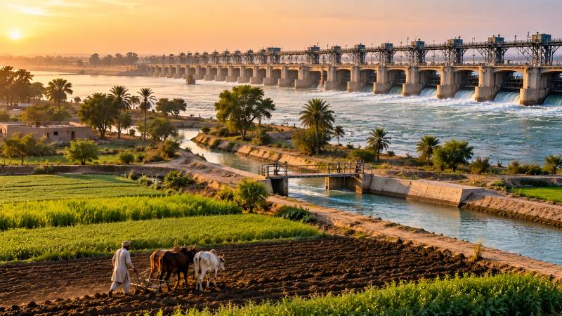
For thousands of years, the Indus decided when the fields of Sindh would receive water. On 13 January 1932, men gathered at Sukkur to announce that the arrangement had changed. Across the river stood sixty-six great steel gates and nearly a mile of masonry. Lord Willingdon, Viceroy of India, had come to inaugurate the largest irrigation undertaking of its kind in the world. Human ingenuity had found a way to make one of Asia's mightiest rivers serve an agricultural calendar.
Sindh had long lived by the moods of the Indus. Rainfall was scant, summers fierce, and cultivation depended upon water arriving from distant mountains. Farmers cut inundation canals into the riverbanks and waited for the annual flood. Some years the river obliged; others it did not. A low flood meant dry fields; a violent one could destroy the channels built to capture its water. The system was ancient and ingenious, but the river remained master of the harvest.
As early as 1855, an engineer named Fife was proposing ambitious improvements to Sindh's irrigation. By the late 1860s, the vision had taken shape of a great barrage at Sukkur, regulating the river's level so that canals need no longer depend entirely upon the natural flood. The idea was audacious. The Indus carried immense volumes of sediment, and its shifting bed presented formidable obstacles. For decades the proposal travelled through surveys and government files. Fife's vision outlived him. Then came the disastrous low inundation of 1918. The river failed to rise sufficiently, canals ran short of water, and cultivators suffered heavy losses. The vulnerability of the old system could no longer be dismissed as a theoretical problem. Fife had supplied the vision. The failed inundation supplied a terrible reminder of why it mattered.
Eventually Arnold Albert Musto developed a workable scheme, with Sir Charlton Scott Cholmeley Harrison directing its construction. Sanctioned in 1923 at an estimated cost of 200 million rupees, an extraordinary sum for the time, work began as men and machinery converged upon Sukkur. In Ipswich, an old manufacturing town in Suffolk, eastern England, the workshops of Ransomes & Rapier produced the great steel gates destined for the Indus. They travelled thousands of miles from an English industrial town to a river whose waters had sustained civilisations long before England possessed a workshop. At Sukkur, sixty-six openings, each sixty feet wide, divided a structure stretching nearly a mile across the river. Massive foundations resisted the water forcing its way beneath the masonry. Above them rose the steel gates. But the barrage itself was only the beginning.
For thousands of years, the Indus decided when the fields of Sindh would receive water. The barrage changed that arrangement, allowing human ingenuity to make one of Asia's mightiest rivers serve an agricultural calendar.
Seven great canals departed from its banks. They were not modest irrigation channels; they were artificial rivers. The Nara Canal had a bed width of 346 feet, the Rohri 247 feet. Consider the original Suez Canal, which opened in 1869 with a water-surface width of approximately 171 feet. The measurements are not strictly comparable, but they convey the astonishing dimensions of the waterways being created across Sindh. And these canals were not built for ocean-going ships. They were built to carry water to fields of wheat, rice and cotton. From the seven main canals spread an intricate network extending thousands of miles. Water travelled by gravity, following gradients calculated with extraordinary care. A small error in level could leave fields many miles away without water.
The age that built Sukkur was fascinated by engineering. The Panama Canal had opened less than twenty years earlier; aircraft were beginning to cross oceans. At Sukkur, the ambition was different. No passenger would buy a ticket to travel upon these canals. Their cargo was water, and their destination was the cultivated field. Contemporary accounts spoke of 77,000 men employed over nine years. Musto and Harrison supplied the engineering leadership, but it took thousands of largely forgotten workers to turn their designs into an agricultural landscape. They excavated enormous channels, laid foundations, built embankments and assembled machinery. What existed first in the imagination of engineers had to be brought into existence by human hands.
In January 1932, TIME magazine described a project capable of irrigating an area as large as Massachusetts, Rhode Island and Delaware combined. The masonry alone, it reported, could have formed a wall six feet high and 520 miles long. The original scheme was designed to irrigate five and a half million acres annually. But the true measure of the undertaking would emerge not from the dimensions of its masonry, but from the harvests that followed. Within a few years, cultivation had expanded across the barrage command. Crops that had depended upon uncertain inundation could now be grown with greater confidence. Cotton nearly trebled. Wheat quintupled, agricultural markets developed, and towns such as Nawabshah and Mirpurkhas grew with the expanding economy of irrigated agriculture. What had begun as lines upon survey maps was becoming a new agricultural geography.
Yet the struggle with the Indus did not end on inauguration day. The river carried more than water; it carried the eroded earth of a vast watershed. Soon after the barrage began operating, excessive sediment entered the right-bank canals. Water could be directed through steel gates. Silt proved less obedient. At the hydraulic laboratory in Poona, engineers studied the problem through physical models. They experimented with currents, channels and barriers until a remedy emerged. Ten original barrage openings were closed, and river-training works, including an artificial island and a submerged weir, redirected the flow. The modifications involved compromises, but improved conditions at the troubled canal entrances.
The river had resisted the original design. The engineers responded by observing, experimenting and learning. That, too, was part of the achievement. Meanwhile, a quieter transformation was unfolding across the plains. Water travelled into fields and settlements whose fortunes had previously depended upon the river's seasonal rise. Farmers could plan cultivation with greater confidence. Markets developed, roads followed the canals, and agricultural life acquired a new measure of predictability.
The benefit was measured not only in acres but in lives organised around a more dependable supply of water. This was not the beginning of irrigation in Sindh. Its people had managed the Indus for centuries. The barrage did not invent that relationship; it changed its scale, reach and reliability. Today, these canals belong so completely to the landscape that it is difficult to imagine Sindh without them. A farmer waiting for his water turn may never have heard of Fife, Musto or Harrison, or of the Ipswich workshops and the thousands of forgotten workers who built the system. Yet the water approaching his field travels through an inheritance conceived nearly a century ago. The true monument was not merely the structure across the river, but the country that would grow around its canals. The Indus continued towards the Arabian Sea, as it always had. But beyond its banks, a different landscape was taking shape. The desert had learned to drink on a schedule