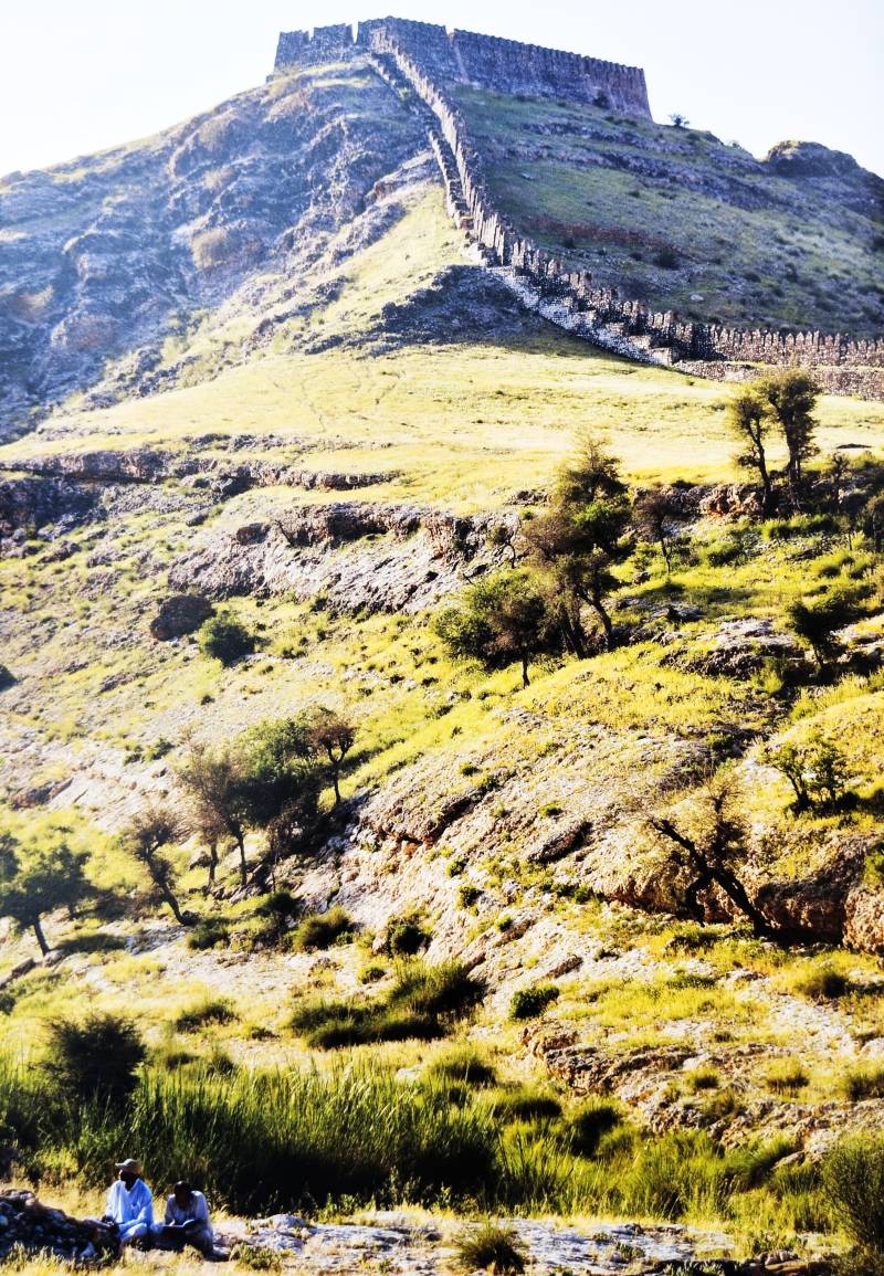
Ranikot, also called the Great Wall of Sindh, is a fort listed as a historical site under the Activities Act of 1975. This impressive fort has been on the UNESCO Tentative List since 1993. The questions of who built this fortress, when, and why, remain a mystery. Numerous stories surround this fortress. Some scholars believe that it was built by the Talpur Amirs of Sindh, while others think the Rai Kings were responsible. There are also experts who suggest it was constructed by the Sasanians, Scythians, or Indo Greeks. Local people even believe that it was built by ghosts, with a peak standing in the middle of the fort. The story of its construction, however, begins with the Achaemenid Kings of Ancient Persia (Iran).
Ranikot was an economic and military powerhouse for the Persians in Sindh and is the best example of Achaemenian Architecture and Engineering in the Indus Valley Region. Achaemenid Architecture was influenced by Mesopotamian, Assyrian, Egyptian, Elamite, Lydian, Median, and Greek dynasties. The Arg-e Bam fort in the Kerman Province of Iran is contemporary to Ranikot Fort, built by Achaemenid Kings around the 4th to 6th centuries BC. The Arg-e Bam fort had 38 watchtowers and 4 gates.
The Achaemenian Dynasty was founded by King Cyrus II of Persia, commonly known as Cyrus the Great, who ruled the Persian Empire from 559 to 529 BC. He overthrew Median sovereignty, uniting all of Iran under one flag and creating a strong and united country. Cyrus the Great ruled from Persia to the Near East, the Aegean Sea, and the Upper Valley of the Indus River in the east. In the Holy Bible, he is called the Liberator of the Jews who were captive in Babylonia (Ezra 1:1-4). Cyrus the Great had capitals at Ecbatana (Hamadan), Pasargadae, and Babylon.
According to the author of The Ancient Buddhist Civilisation of the Swat, Peshawar, Kabul and Indus Valleys (New York 2011), “Around 535 BC, Cyrus the Great crossed the Hindu Kush Mountains to enter the fertile Valley of the Kabul River and succeeded in conquering the region up to the banks of the Indus River. At that time this region was inhabited by a large number of small farming communities. The Achaemenids brought the entire region west of the Indus River under one satrapy, the Satrapy of Gandhara. Gandhara became a single political unit and was governed by a Satrap who enjoyed the full confidence and support of the powerful Achaemenid emperor” (Page 31 and 32).
The capital of the Satrapy of Gandhara was Pushkalavati, Peuceloitus or Proclais. Presently, several mounds of this ancient city can be seen near Bala Hisar or Charsada in the Peshawar Valley. According to legend, Lord Rama’s brother Bharata and his wife Mandavi (a cousin of Sita) had two sons named Taksha and Pushkal. After the conquest of the Gandhara region by Bharata, two cities emerged there, named after Bharata’s two sons: Taxila from Taksha and Pushkalavati (Peshawar) from Pushkal. Sir John Marshall (1904) discovered a pedestal bearing the inscription “In the district of Pushkala”. Sir Mortimer Wheeler excavated Charsada in 1958 and 1962, identifying structures belonging to the Achaemenid Period (5th Century BC). Megabazus, son of Megabates, was Satrap of Arachosia, Gandhara, and Paricania during the Achaemenid period. The Gandhara Satrapy was established in 518 BC.
After the death of Cyrus the Great, his son Cambyses succeeded to the throne in 529 BC. He invaded Egypt, Cyprus, Abyssinia, and Libya. The Egyptian Campaign started in 525 and ended in 522 BC. On March 11, 522 BC, a revolt arose against Cambyses, in which he was killed by the Persians. Cambyses died without leaving a son. His tomb is believed to be in Zendan-e-Suleiman in Pasargadae and the Takht-e-Rustam near Naqsh-e-Rustam, in the Fars province of Iran. He had served as Governor of Babylon during his father’s rule.
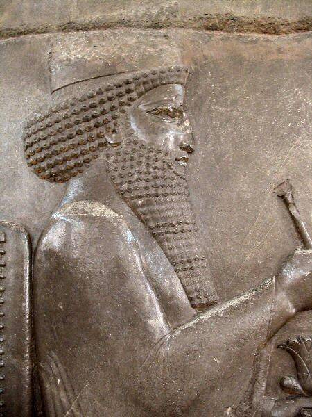
As Cambyses had no male children, there was a lot of chaos and confusion in the Royal Court of Persia. Finally, all the Persian nobles chose a young prince of the Royal family named Darius, the Mede. Born in 550 BC, Darius the Great was the son of Hystaspes, a Satrap of Bactria in 522 BC. He had served King Cambyses as a spear-bearer in Egypt. Darius the Great became Emperor of Persia in September 522 BC. Darius the Conqueror pursued territorial expansion from 520 to 486 BC. During this time, the Persians went to Europe, faced the Ionian Revolt, and moved from Thrace to Memphis. At the age of 62, according to the book of Daniel 6.3, Darius the Great took over the Kingdom of Babylon from King Belshazzar, the son of King Nabonidus and grandson of Nebuchadnezzar. Darius the Great focused on construction projects at Susa, Pasargadae, Babylon, and Egypt. According to rock inscriptions, Darius fought 19 battles and captured 9 kings. He died in 486 BC at the age of 64.
Scylax of Caryanda was a Greek explorer and writer of the late 6th and early 5th centuries BC. He was active between 600 to 501 BC. His own writings are lost, though occasionally cited or quoted by later Greek and Roman authors. He provided the first account of the Indus Valley, its people, and cities. Perhaps, he wrote the first book about India. He was a Greek captain, whom King Darius the Great employed to explore the course of the Indus River from Kaspapyros to the Indian Ocean. According to some scholars, Kaspapyros must have been on the banks of the Cophen or Kabul River. Darius the Great wanted to connect the Indus Valley, Persia, and Egypt for international trade.
According to the Cambridge History of India, Rapson and Edward James, Volume 1, 1922: “Sometimes about 517 BC, Darius dispatched a naval expedition under Scylax, a native of Caryanda in Caria, to explore the Indus. The squadron embarked at a place in the Gandhara country, somewhere near the upper course of the Indus, the name of the city being Kaspatyros (Hdt.IV,44,cf,III,102) or more accurately, Kaspapyros (Hecataeus, Fragm.179). The exact location of this place is still a matter of discussion, but the town may have been situated near the lower end of the Cophen (now Kabul) River before it joins the Indus. The fleet, it is recorded, succeeded in making its way to the Indian Ocean and ultimately reached Egypt, two and one-half years from the time when the voyage began” (Page 336).
Describing the Conquest of the Valley of the Indus, Sami us Samad, the author of The Ancient Buddhist Civilisation of the Swat, Peshawar, Kabul and Indus Valleys (New York 2011), writes, “Then in 518 BC the Achaemenid forces once again crossed the Himalayas to conquer new territories. The forces under Darius the Great crossed the Indus River and conquered the region between the Indus and the Jhelum Rivers. They established the second Achaemenid Satrapy in the newly conquered regions, the Satrapy of Sindh (Sindh referring to the Indus River, which was called Sindhu in ancient times, and not to the province of Sindh in present-day Pakistan). Taxila became the capital of the Satrapy of Sindh and a similar process of consolidation was initiated in the Taxila region” (Page 32).
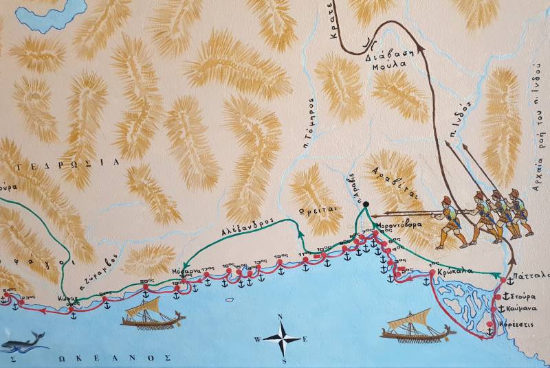
Ainan Ahmed writes in his book The Game of Power-Volume 3 (History of Persian Empire), 2024, that, “In 516 BC, Darius embarked on a campaign to Central Asia, Aria and Bactria, and then marched into Afghanistan to Taxila in modern-day Pakistan. Darius spent the winter of 516-515 BC in Gandhara, preparing to conquer the Indus Valley; The Sindh region. Darius conquered the lands surrounding the Indus River in 515 BC. Darius I controlled the Indus Valley from Gandhara to modern Karachi and appointed the Greek Scylax of Caryanda to explore the Indian Ocean from the mouth of the Indus to Suez. Darius then marched through Arachosia and Drangiana back to Persia” (Page 44 and 45).
In Oarus (Volga River), Darius the Great had built 8 large forts, some 8 miles (13 kilometers) distant from each other. Arius, seeing nothing more of them, left his forts half-finished and returned towards the west. For the frontier defense, he might have built some other forts. It seems that the royal fortress of Opiai was also built by Darius the Great during his conquest of Hindus (Sindh) Province in 516 BC. There were many Kingdoms or City-States in the Hindush Satrapy, such as Mousikanus, Sambus, and Pattala.
Ruins of the Achaemenid Great City at Bhir Mound, Taxila
At the time of the Achaemenid conquest, a small settlement existed at the village of Bhir Dargahi, Taxila. The Achaemenids constructed their capital city near this settlement at Takshasila Bhir Mound. The distance from Bala Hisar Fort, Hashtnagri, Peshawar Khyber Pakhtunkhwa to Taxila, Rawalpindi Punjab is 153 km. The archaeological excavations at Bhir Mound, carried out by Sir John Marshall from 1913 to 1925, revealed heavy masonry of buildings belonging to the Achaemenid City at the lowest stratum of the archaeological site. The ancient ruins of Taxila date back to 800 to 525 BC. After the continuous rule of the Mauryans, Scythians, Parthians, Kushans, and Huns, Gandhara started declining from 463 to 1025 AD.
The Inscription of the Tomb of Darius the Great and Conquest of Hindus (Sindh) Province
An inscription (DNa) in the upper register of the Tomb of Darius the Great at Naqsh-i-Rustam, 13 km north of Persepolis in Fars province, Iran, reads: “King Darius says: By the favour of Ahuramazda these are the countries which I seized outside of Persia; I ruled over them; they bore tribute to me; they did what was said to them by me; they held my law firmly, Media, Elam, Parthia, Aria, Bactria, Sogdia, Chorasmia, Drangiana, Arachosia, Sattagydia, Gandhara, Hindus (Indus/Sindh), the haoma drinking Scythians, the Scythians with pointed caps, Babylonia, Assyria, Arabia, Egypt, Armenia, Cappadocia, Lydia, Yauna (the Greeks), Saka (the Scythians across the sea), Thrace, the petasos wearing Greeks (Yauna), the Libyans, the Nubians, the Men of Maka and the Carians.” The king stands on a huge platform, supported by 28 figures in two rows of 14, representing the lands of the empire. This is a trilingual inscription in Old Persian, Elamite, and Babylonian languages. These six inscriptions DB, DPe, DSe, DNa, DSaa, and XPh have lists of 23, 24, 27, 29, 23, and 31 satrapies or provinces.
Hekataios of Miletus (500 BC) and his Classical Works
Hekataios of Miletus, son of Hegesander, was a Greek philosopher, historian, and geographer. He was born in 550 BC at Miletus, Turkiye, and died in Ionia, Greece in 476 BC at the age of 74. He was one of the ambassadors to the Persian Satrap Artaphernes to negotiate from Ionians in 494 BC. He compiled two works entitled 1) Periegesis (Travel around the Earth or World Survey) and 2) Genealogiai (Historiai: A Systematic Account of the Traditions and Mythology of the Greeks). Over 300 fragments of Periododges are preserved, mostly as citations for place names in the work of Stephanus of Byzantium, who lived during the 6th century AD. We find descriptions of Indos or the Indus River on pages 16 and 17.
According to the Cambridge History of India, Rapson and Edward James, Volume 1, 1922:
“Hecataeus of Miletus had probably already given forth his geographical work, the Periodos Ges, before 500 BC. At the extremity of his field of vision there was some vague picture, derived from Scylax and the Persians, of the Indian world. His knowledge stopped on the frontier of the Persian Empire, the River Indus. Beyond that was just a great desert of sand. But the name of the people called Gandhari on the upper Indus had reached him, and the name of a city in that region, whence Scylax had started on his expedition down the river: Hecataeus wrote it as Kaspapyros. He mentioned the names of other Indian peoples too of the frontier hills: Opiai, Kalatiai are the ones preserved in his fragments- and a city of India which he called Argante”.
The Royal Fortress of Opiai in Achaemenian Sindh
D Graham J Shipley, author of Geographers of the Ancient Greek World: Volume 1 (2024), writes:
Opiai of India Opiai: an Indian nation. Hekataios, Asia: “among them live people along the river Indos, the Opiai: and in (their land is) a royal fortress. The Opiai (extend) up to this point; but beyond there is a desert up to the Indians”. (144.3 HEKATAIOS). Richard Stoneman writes in his book The Greek Experiences of India from Alexander to the Indo Greeks (2021) that, “Herzfeld 1968, 282 argues the sandy desert is the Thar desert which lies east of the Indus, and that the Opiai must therefore be in Sindh (cf.Plin.NH 6.21; Mc. Crindle 1927, 112). The descendants of Opiai are Ibrai, Abhira or Abra, a warrior tribe of Sindh.
There are three Rumi graves (up to 1991) with an east-west direction 2 km east of Sann Gate. According to locals, there were 15 to 20 Rumi graves. Most of them were washed away by flash floods and rainstorms in 1985. Zafar Kazmi, Director of the Sindh Provincial Museum, Hyderabad, points out some ancient caves in this area that were used by humans in the past. He saw some wild animals engraved on a pillar and identified inscribed signs which resembled Greek or Roman. Nowadays, there is no trace of such engravings and signs. They may have all collapsed or eroded. Some Zoroastrian symbols are also discovered from Ranikot, showing Persian influence in the area.
Nerunkot under the Rai Buddhist Kingdom of Sindh 640 AD
Nerunkot was a central place during the Rai Buddhist Kingdom of Sindh in 640 AD. There are many caves which can be linked with the Buddhist faith that prevailed in the Budhia Region (Sehwan to Jhal Magsi Gundava) of Sindh. Such ancient caves are identified beside Tori Dhoro, Pariyan Jo Tar (Pond of Fairies), and Duhul Dhoro. These caves resemble the Gondrani Caves, 20 km northwest of Lasbela, Balochistan. Some flint and potsherds of Gondrani Caves bear a resemblance to Pre-Indus cultures. The Buddhist/Pre-Islamic period pottery has been found at the Murdari Dhoro, Wagu Tar (Crocodile Pond), and near Mohan Gate. According to Chachnama, there was a Buddhist Stupa inside Nerunkot, which was demolished by Arabs and a mosque was built on that platform during the Conquest of Sindh 711 AD. Some Buddhist period potsherds have also been found from the Ranikot area. Beside Nerunkot, Debal, Sehwan, Brahmanabad, Alor, and Siwi were main capital towns in Sindh.
Muhammad Bin Qasim Captures Al Nerun fort in 711 AD
According to Chachnama: A History of the Arab Conquest of Sindh (711 AD), after conquering the port city of Debal, Muhammad Bin Qasim brought his army against the walls of Nerunkot. On the arrival of the Arab army at Nerun, Muhammad Bin Qasim wrote a letter to Hajjaj: “After travelling many a stage, we halted by a fort, which was situated on the hills of Nerun. There was a pond in its vicinity whose water was brighter than the eyes of a lover, and whose meadowland was more pleasant than the garden of Iram”. Springs in Ranikot are covered with green grass and wild plants. These have a good number of fish. There are some graves inside Ranikot which are called Ashabiyan Joon Qabroon, or Graves of the Companions of Prophet Muhammad (Peace Be Upon Him). One grave is 33 feet long and is located 2.6 km east of Meeri Kot on the bank of a rivulet. The Pond of Crocodiles lies close to it. These may be the graves of some Arab soldiers or religious leaders who accompanied the Arab general Muhammad Bin Qasim. Remains of an old mosque, halls, rooms, and cells are found near Shergarh and Murdari Dhoro. The Gabol villagers used to offer Eid Prayers here. Remains of Mehrab suggest another mosque near Ashabiyan Joon Qabroon. MH Panhwar, quoting Chachnama, writes in his book The Chronological Dictionary of Sindh (1981): “After the fall of Debal, Muhammad Bin Qasim sent siege machines by river to Nerun and he advanced to it by land. Buddhist priests supplied the Arabs with provisions all along the route. Asamani (Buddhist), who was the Governor of Nerun, voluntarily surrendered the fort and town to the Arabs. The inhabitants sent two Buddhist priests to Hajjaj and made a treaty with him” (Page 137).
Ranikot: A Place of Refuge for Mughal Emperor Humayun in 1543 AD
Jouher Aftabchi was in the service of Humayun. He writes in Chapter XIII that "His Majesty marches from Sinde and proceeds towards Candahar" in 950 AH / 1543 AD.
Further, we learn that:
“When the ambassador, Baber Kuly, returned to his master, and informed him that the King was ready to quit the country on certain conditions, he agreed to send to his Majesty 2000 loads of grain, and 300 camels, to be delivered at the village of Rutay or Runay, from which place he assured the King that he might procure all other requisites for proceeding to Candahar. In consequence of this amicable agreement, his Majesty put all his baggage on board boats, crossed the river, and halted in the village of Rutay, till the grain and camels arrived; soon after which a distribution was made of them all to all the followers; after which we proceeded towards Suhan (Sehwan)” (Page 49).
I have identified the village of Runai as Runi Nai or Ranikot fort.
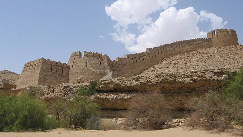
The Great Wall of Sindh
The Ranikot fort got its name from a hill torrent called Nai Runni which collects water from the Khirthar Laki Range (21000 ft above sea level) and drains into the Indus River at Sann, a historical village of Jamshoro, Sindh. In the Sindhi language, the words Runni, Rooni, Runai, Reni, Ren, and Ran are also used for water flow. Some other names of this historic fort are Runay, Runna, Ranoo Kot, and Rani Ka Kot. When this fort was built on the banks of Nai Runni, people called it Nai Ranni Kot. Later on, this place came to be known as Nerunkot which means the fort which stands on Nai Ranni. Some people mistakenly call it Rani Kot or the Queen’s Fort, which is completely wrong and baseless.
Some modern authors like Salman Rashid believe that Nerunkot stood at the present site of Hyderabad, while some scholars like Badar Abro view that it was the Ranikot area. A Persian geographer and traveler, Ibn Khordadbeh (d.912 AD), the author of Kitab Al Masalik Wal Mamalik (Book of Roads and Kingdoms), describes Multan, Mansura, Makran, Debal, Nerun, Alore, etc.
At the time of the Achaemenid conquest, a small settlement existed at the village of Bhir Dargahi, Taxila. The Achaemenids constructed their capital city near this settlement at Takshasila Bhir Mound
As far as my research is concerned, Al Istakhri, in his Map of Sindh (951 AD), has shown Al Debal, Al Nerun (Al Berun), and Sadusan (Sehwan) on the right bank of the River Indus in a straight line. On the other hand, we also have clear evidence from Ibn Haukal’s Map of Sindh dated 976 AD. It clearly shows Al Debal, Al Nerun, and Manjabari. These are undoubtedly the locations of Bhambhore, Ranikot, and Moj-Amri on the right arm of the River Indus. Sehwan and Qandabil (Jhal Magsi Gundava), Qusdan (Khuzdar), and Kirkanan (Kalat) are also shown on this route. Therefore, it is quite clear from this map that Al Nerun is the present fort of Ranikot. A third piece of evidence is the Map of Al Idrisi (1154 AD). He was an advisor to King Roger II of Sicily, Europe, and he also marked Berun or Al Nerun on the western side of the River Indus, Sindh. If Nerunkot were located at the Hyderabad site, all these geographers would have placed it on the left bank of the River Indus. None of these geographers have placed Nerunkot in the east of Sindh. Is any more evidence required? MH Panhwar (2003) writes under Geographical Places Shown in Arab Maps and Their Locations that Nerunkot: Ruins are probably near Khirthar and not Hyderabad? Again, he writes about Nala Sankra and Nerunkot, stating that Nerunkot was a part of Chakarhala Prgana and both were to the west of the river.
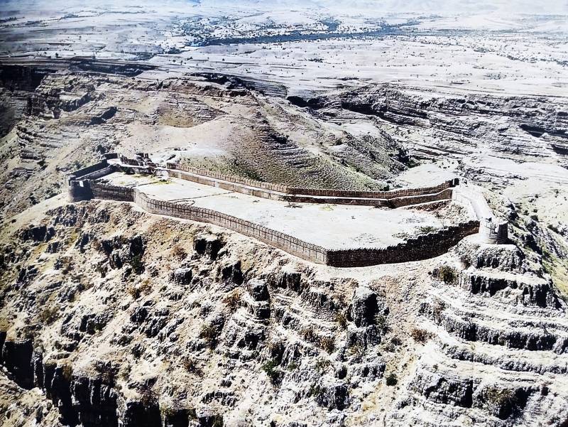
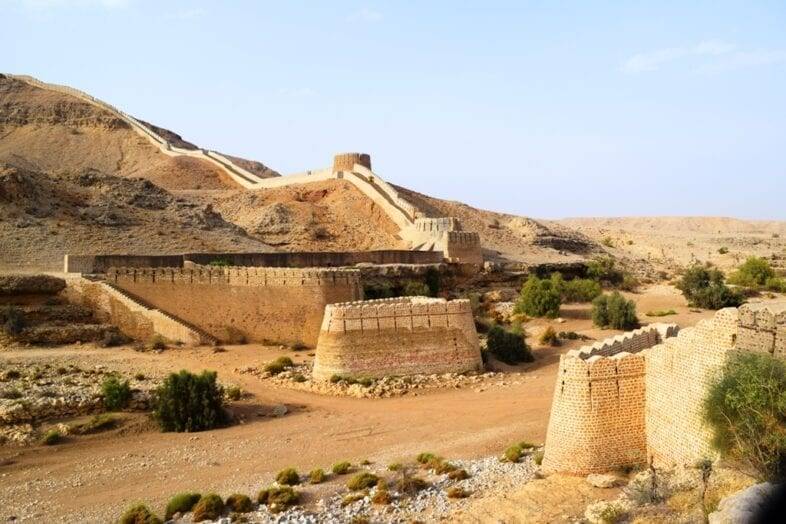
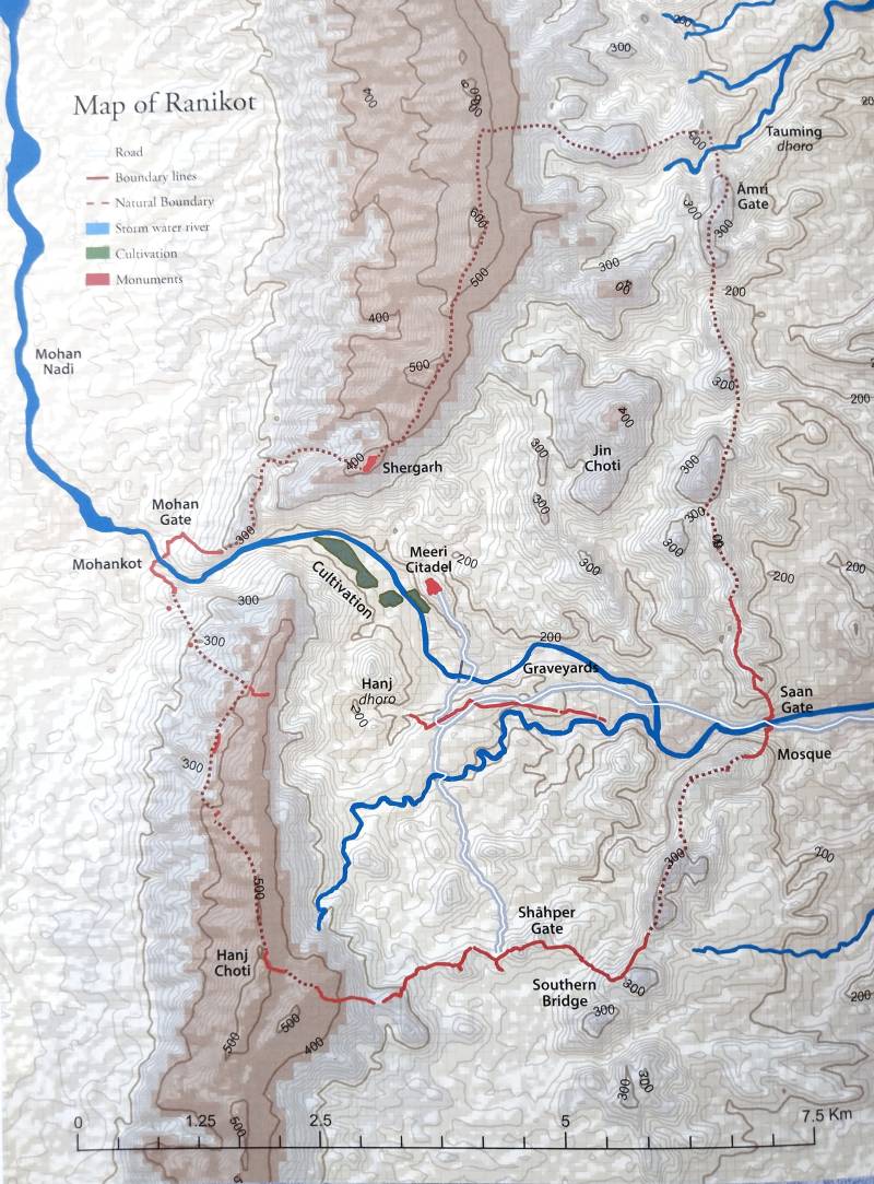
The exact location of Ranikot is 25.85 N to 25.95 N latitude and 67.75 E to 67.85 E longitude. The fort is 19 miles or 31 kilometers southwest of Sann City, which stands on the western bank of the River Indus. The Ranikot fort is situated in Deh Rani Kot, Taluka Thano Bula Khan in District Jamshoro, Sindh. This fort is well connected with Balochistan and Iran through an ancient pass called Peech Wat. This ancient fort was surrounded by Sehwan, Dalel Dero, Brahmanabad, Hyderabad, and Thatta in the past. According to the survey of SEAS, Ranikot's circumference is 20 miles or 32 kilometers. It has 47 bastions or towers, among which 40 are circular and 7 are rectangular in shape. According to Badar Abro, the total manmade wall is 26,353 ft or 8.03 kilometers. It is estimated that 100 masons with 1600 laborers could have completed the fort within 4 years if no break was permitted. The wall of Ranikot resembles the Great Wall of China. It’s made of gypsum, lime, and sandstone. The height of the walls varies between 22 to 12 feet, while the widest wall (between towers 23 and 24) is 10 feet wide. At some points, the narrowest width of the walls is only 3 feet. The wildlife includes foxes, jackals, ibex, crocodiles, pangolins, snakes, and partridges.
The fort has four gates: 1) Sann (eastern gate), 2) Amri (northeastern gate), 3) Shahpeer (southern gate), and 4) Mohan (western gate). Shergarh and Meeri are small fortresses within the large fort. Some of the stone arches have carvings with scrolls of pomegranates, peacocks, and sunflowers. Peacocks, water buffaloes, lions, jewelry, and floral designs are depicted on Muslim graves in Graveyard 2. A fierce battle was fought at Ranikot between Syed IIbrahim Shah Sanai and rebels during the Samma Period. Pieces of Samma period Kashi (ceramics) have also been found in this area. For national and international tourists' facilitation, some huts, a restaurant, a rest house, and an information desk have been established by the Culture, Tourism, Antiquities, and Archives Department, Government of Sindh. Currently, Mohsin Soomro is working here as the in-charge officer of Ranikot.
The general features of Ranikot fort include valleys, passes, hill torrents/springs, reservoirs, ancient caves, archaeological sites, walls, passages, stables, weapon stores, elephant gates, bastions, towers, military barracks, grain storages, a water supply system, bridges, residences, baths, quarters, a lighting system, gardens, worship places, and graveyards. Cannon guns were installed on watchtowers.
During the days of Mian Ghulam Shah Kalhoro (1760-1767 AD), the Cheenjani Khosa Balochis used to live inside the Ranikot fort. There are 500 to 700 people of the Gabol tribe who have lived here since the rule of the Talpur Amirs of Sindh. Captain Preedy, the Collector of Karachi, confirms the Gabol’s presence in Ranikot in 1845. Now, Khosa, Rind, Rustamani, and Khaskheli tribesmen live outside the fort area. Onions are grown in great numbers, beside cotton, in the agricultural lands here. Mostly Nai Rani, Nai Sann, and Nai Mohan irrigate the lands in the area. The area is also irrigated by Darawat Dam, which was constructed in 2010. Ranikot springs discharge 1700 liters per minute. These springs cultivate 100 to 175 acres of land in the area. The distance from Karachi to Ranikot fort is 261 kilometers. The driving time from Karachi via Hyderabad Jamshoro and Sann to Ranikot is approximately 4 hours through the Hyderabad Motorway and Indus Highway N 55S. Ranikot is lush green and pleasant after the monsoon rains, but it is very hot in summer. The best time to visit this majestic fort is from October to March. Everyone has a question regarding the origin of this strong fortress: who built the Ranikot fort? According to Arab News, Naimat Khan (2019) states that this majestic fort was used by Cyrus the Great as his military garrison.
I am convinced that Ranikot fort is a 2,500-year-old royal fortification. Therefore, I would suggest that Ranikot fort was built by Darius the Great during his conquest of the Hindush (Sindh) Province in 516 BC. We do not have any written record, inscription, or stela to prove this claim except for Hekataios fragments. Salman Rashid opines that Ranikot was built perhaps 2000 years ago. Colonel Rashid is of the opinion that the fort was built by the Scythians (200-100 BC). MH Panhwar has concluded that the fort was built either by the Indo-Greeks between 145 to 90 BC, or by the Scythians around 74 BC.
The surface collection and study of Ranikot suggest that the area was inhabited before the construction of this mighty fort. Here, human occupation has been divided into four phases: 1) Prehistoric and Protohistoric, 2) Achaemenid (Persian) and Indo-Greek, 3) Pre-Islamic Scythians, Hindu, and Buddhist periods, and 4) Muslim Period Arab, Samma, Tarkhan, Mughal, Kalhora, and Talpur dynasties.
According to the Sind Gazetteer (1874), Ranikot was last repaired by the Talpur Amirs of Sindh around 1812 AD. They spent 12 lacs of rupees on the repair of this fort within 4 years. The Talpurs named this fort Ali Abad. Nawab Wali Muhammad Khan Leghari, the Prime Minister of Sindh and Governor of Larkana, was overall in charge of this work. He was assisted by Nawab Bahadur Khan Khokhar. Others who supervised this work were Nawab Noor Shah, Nawab Ghulamullah Leghari, Nawab Soomar Jakhro, and Nawab Darya Khan Nizamani. Ghulam Ali Mail composed verses on the completion work in 1230 AH (1815 AD). Later on, Alexander Burnes (1830), Edward Paterson Del Hoste (1832), Captain Preedy, Collector of Karachi (1845), AW Hughes (1874), GM Syed (1925), Shamsuddin Qureshi (1942), HT Lambrick (1946), Colonel Rashid (1963), Taj Sahrai (1981), MH Panhwar, Dr. Nabi Bux Khan Baloch, Badar Abro, and Ishtiaque Ansari have discussed Ranikot in their research works.
Antiquities
Among the important antiquities discovered at Ranikot are copper coins. According to MH Panhwar, some Mughal period coins were found from the walls of Ranikot fort, particularly from Meerikot, the central place of the fort. Some copper coins from Ranikot, especially from Meeri Buthi and Wagu Tar (Crocodile Pond), have been found. Important among these are 1) Arab ruler Abd Allah, Habbari (AH 256 -870 AD), Mansura Mint, 2) Tanka of Sikandar Shah Lodhi (AH 919-1513 AD), and 3) a copper coin of Mughal Emperor Humayun (AH 937 -1530 AD), Lahore Mint. Taj Sahrai (1981) had also obtained some coins from his Gabol friends. He also found two iron heads from Ranikot.
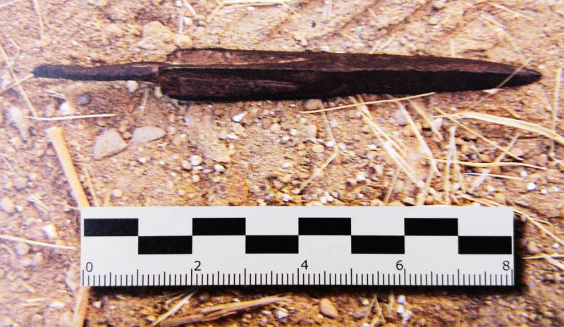
Another interesting finding is the iron arrowheads which have been found in the Ranikot area. Among these are 1) Triangular shape arrowhead length 8.5 cm, with 10.5 grams weight and 2) Arrowhead length 8.5 cm, with 10 grams weight. These arrowheads show the presence of Scythians in Ranikot dating back to the 3rd Century BC. Please see photos in Ranikot: The Wall of Sindh (2019).
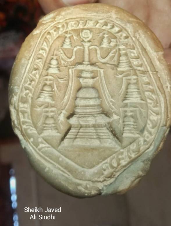
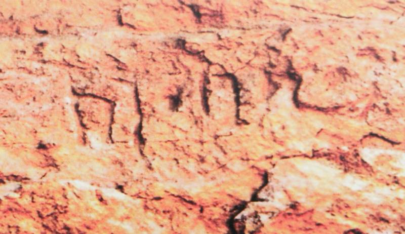
In March 2018, three inscriptions and markings were found on the southeastern corner of Ranikot. Inscription No.1 (engraved on a cliff) was sent to Dr. Nasim Khan of Peshawar University. This consists of nine symbols. According to him, this inscription belongs to the Gupta Period (4th/5th Century AD). Recently, in June 2024, a clay sealing was also discovered by the Archaeology staff in Larkana from Jhukar Jo Daro. It shows social, cultural, and religious links between Ranikot and Jhukar, as both sites stand on an ancient trade route which connected Sindh with Afghanistan, Iran, and Central Asia.
History of Restoration Work, Documentation and Literary Activities at Ranikot
The first restoration work of Ranikot fort was undertaken by Mian Noor Muhammad Kalhoro in 1720 AD, while Nawab Wali Muhammad Khan Leghari, the Prime Minister of the Talpur rulers of Sindh, restored the fort in 1812 AD. Nai Sann destroyed part of the northwestern wall of Ranikot in 1827. It was documented by the British Government of India in 1876. With the efforts of GM Syed and the Dadu District Administration, a bungalow and road were constructed for tourists in 1936. A two-day Bazm e Sufia Sindh Conference was organised by GM Syed on November 18, 1966, to promote the culture of Sindh. Camels and jeeps were used for visiting Ranikot at that time. Following scholars of Sindh visited Ranikot on November 20, 1966.
Later on, Syed Pir Hisamuddin Rashdi, Muhammad Ibrahim Joyo, Shaikh Ayaz, Ghulam Rabbani Agro, MH Panhwar, and Colonel Rahid also visited this fort with the facilitation of GM Syed. The Deputy Commissioner of Dadu organised an International Seminar on Ranikot on March 26, 1981. Mr. SM Abbassi, the Governor of Sindh, was the Chief Guest of the event during this conference. Ghulam Rabbani Agro published Quarterly Mehran Ranikot Number in 1984. Since then, Ranikot has become a part of Sindhi literature. Many stories, novels, and pieces of poetry have been composed by authors and poets including Shaikh Ayaz, Momin Maleerai, Amar Jalil, Zawar Naqvi, and others. The Sindh Exploration and Adventure Society (SEAS) conducted a detailed survey and pitched tents in Ranikot in 1990. The team was led by Dr. Kalimullah Lashari, Syed Jalal Mehmud Shah, Syed Munir Shah, Sadiq Gabol, Badar Abro, and Anwer Pirzado. Restoration work at Ranikot fort was initiated by the Archaeology Department of Pakistan, the Department of Culture Government of Sindh, and the Dadu District Administration. After mismanagement and allegations, the ill-planned restoration work was stopped in 2005.
An archaeological survey was conducted at Ranikot on January 30, 2009. Italian archaeologists Paolo Biagi and Renato Nisbet visited the Ranikot area to find out the possible flint source for the production of prehistoric chipped stone artifacts. This led to the discovery of many small charcoal fragments (0.5-2.0 cm) from a collapsed pillar near the Sann Gate. The acacia charcoal sample was sent to Groningen Radiocarbon Laboratory, Netherlands. According to the laboratory AMS Radiocarbon Date from Sann (eastern) Gate tests, it was found that the pillar was erected between 1720 and 1828. This was the time of Mian Noor Muhammad Kalhoro and Mir Karam Ali Khan Talpur. The archaeologists and experts should collect original material for carbon dating. A Polish travel blogger, Eva Zu Beck, visited Ranikot in January 2019. She has visited 60 countries with 1.76 million subscribers on her YouTube channel as of January 2024. Many people also talk about fabulous gold treasures found in this fortress.
What can be done to explore the Ranikot site further?
Abdul Hameed Akhund, Secretary of the Endowment Fund Trust for the Preservation of the Heritage of Sindh (EFT) Karachi, has published a beautiful book Ranikot: The Wall of Sindh in 2019. This book is written by Badar Abro. We should explore the fort more. Scientific excavations, surveys, and surface collections can be so helpful to us. National and international universities should be invited to document Ranikot fort.
The Government of Sindh should, for its part, at least establish a museum, photo gallery and a library at Ranikot.