The establishment of Murree and the development of the small cantonments along the 60 km mountain range towards Abbottabad was due to a combination of factors but the most overriding was the health of troops. After the annexation of the Sikh kingdom, the bulk of the troops of the Army of Bengal was based in the area known as Greater Punjab, which included the valley of Peshawar-Mardan. The morbidity and mortality rate of British troops was very high due to malaria, cholera and typhoid, as well as the heat and humidity of the plains. The British had already established over 20 large and small ‘hill stations’ in India, where it was observed that there was a decrease of 50 percent in sickness and death in troops and families living there.
In 1850, a committee was formed by the Punjab Administration to select the site for a sanitarium in the mountains. One of the members was Capt Abbot of Abbottabad fame, who was one of the first Englishmen to camp in the pastures of a ridge near the village of Musiari that later became Murree. As Boundary Commissioner Hazara, he had convinced the Punjab Administration that the Hazara and the Murree Hills should not be included in the new Sikh State of Kashmir that had been sold to Gulab Singh. The committee ultimately selected the present site because it was relatively easy to access from Rawalpindi and the elevation of 2,000 meters ensured a cool climate in summer. Historically, the Murree Tehsil, which included Barian, was part of the Hazara Administrative division, but was transferred to Punjab before it was finally selected as a Hill Station. That same year, the first batch of a 100 British invalids were housed for the summer in a temporary camp on the Murree ridge and in 1853 the first barracks were constructed.
The cantonment on the Kuldana Ridge with the well-spaced out barracks circa 1920
In 1855, the local Dhund tribe sold an area of 14 villages for a price of Rs. 2,054 – paid partly through remissions in land revenue but mostly as compensation. The members of the tribe innocently thought that the British would not be able to bear the sense of isolation in the dense forests or withstand the winters. But the Englishman was here to stay, and the Administration offered land at Rs. 50 per acre to encourage the English to build bungalows. Following the revolt in 1857, there was a surge in construction in the 3.5 miles that connected Pindi Point to Kashmir Point, with the focus in the middle that now constitutes the Murree Mall.
Murree was the second-largest hill station after the summer capital of the Bengal Presidency at Simla, and in 1870, it was occupied by the Chief Commissioner of Punjab and his staff as their summer residence. However, due to frequent outbreaks of cholera and insufficient water, the administrative HQ in Lahore moved back to Simla in 1876. However, Murree remained the summer headquarters of the Bengal Army that later merged under the headquarters of Northern Command. Consequently, Murree and its surroundings were essentially for the military and were split into a number of cantonment areas. Northern Command had an area on the Mall and on a spur heading down from Pindi Point were the Cliffden Barracks which was a family camp for senior British other ranks, and was later designated as a cantonment. Towards the other side, beyond Kashmir Point, the Murree Ridge branched off towards the richly wooded areas of Upper and Lower Topa and Gharial Cantonments to the east, and Kuldannah to the west. The troops were initially living in tents, but gradually barracks for the soldiers and suits of rooms for the officers emerged.
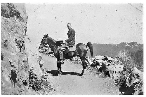
A rider on a section of the road between Changla Gali and Kuza Gali in 1920. The road was still not motorable
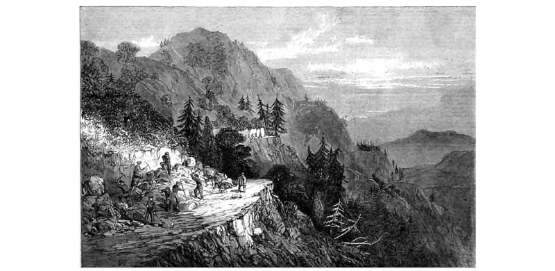
Initially, a six-feet-wide mule track that traversed some dangerous cliff faces near Changla Gali and short of Dunga Gali, connected Murree to the military encampments on the way to Abbottabad. However, due to the frequent troubles in Hazara, there was an acute need of converting the track into a proper road for the movement of troops and for this reason it came to be known as the ‘Military Road.’ The use of British troops as volunteer labour for constructing the 60 km road was conceived by Gen Sydney Cotton, GOC Peshawar Division. From some of the British battalions like the 79th Queen’s Own Cameroon Highlanders, close to 650 (or more than half its strength) volunteered for 2-3 years running, and in the six months they spent each year constructing the road (May to June), there was no sickness. However, it was at times dangerous work and injuries and fatalities did occur.
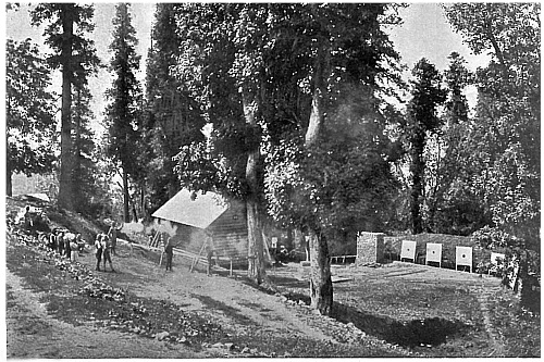
The revolver firing range at the Changla Gali School of Musketry 1889
Work started in 1863 and on some stretches, the road was expanded to 12 feet. However, it was not so on the lower reaches of the Nathia–Abbottabad Section, where the weather was hotter. In 1868 when the Green Howards marched from one of the cantonments for taking part in the Black Mountains Expedition, in places the track could barely take a horse. A skilled soldier was paid 10 annas per day and an unskilled soldier 6 annas. They were issued a course blue-grey flannel jacket and trousers, and worked from 5 am to 11.30 am to avoid the strong afternoon sun. The men initially lived in large white tents which contrasted strikingly with the dark green of the pine and fir forests.
As at Murree and its surroundings, the small cantonments along the road to Nathia Gali and beyond were either on ridge-lines or spurs. Three of the cantonments along the Murree–Abbottabad track were reserved for British mountain batteries that were stationed in Rawalpindi in winter. The four ‘native’ mountain batteries were housed in Abbottabad and Kakul. A mountain battery was large in the number of men and 185 guns and pack mules which carried the dismantled guns, ammunition, fodder and all the stores required for the battery to be self-contained. It would have been quite a sight to see over 500 mules and their handlers trudging up to their summer retreat. The first cantonment for the batteries was six miles from Murree on the Khaira Gali ridge at an altitude of 2,350 metres. The ridge commands a fine view of the valley of River Jhelum and the Pir Panjal Range. Another cantonment for the mountain batteries was Kalabagh, a short distance from Nathia Gali. And the last was Bara Gali, at an altitude of 2,400 meters. It was the northernmost of the line of hill stations and cantonments and lay a mile off the main road on a wide platform surrounded by forest.
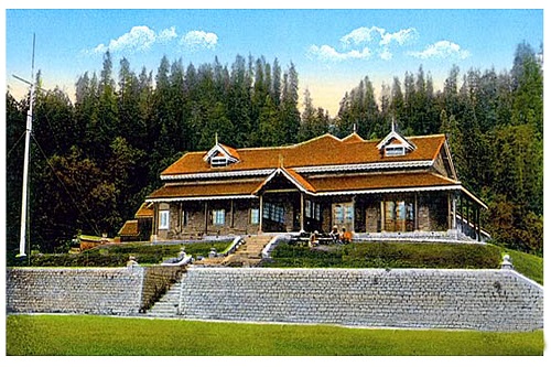
The residence of the Chief Commissioner Peshawar on the ridge connecting Nathia Gali to the base of Miranjani. It was subsequently replaced by the Governor House. Circa 1900
Nathia Gali was not a military station but the summer headquarters of the Chief Commissioner Peshawar, with his residence on the spur connecting the Nathiagali and Miranjani ridges. When the Northwest Frontier Province (NWFP) became a separate entity, the commissioner’s residence was replaced by a much larger house for the governor of the province. Nathia Gali was one of the most beautiful hill stations. Its ridgeline towards Kalabagh to the east and Mukshpuri to the west was thickly clothed by pine, maple, chestnut and oak. In the foreground, to the northeast, rose the green slopes of Miran Jani (3000 meters), and beyond in the far distance the white cone of Nanga Parbat, towered above its neighbors. In its early days, Nathia had seventeen bungalows for European visitors, a small bazaar, a hospital, and a post and telegraph office. An adjunct of Nathia was Dunga Gali, which initially had a small sanitarium but by 1907 it had 15 bungalows along the Wisteria Drive and was favored by the British because of its club with two lawn-tennis courts.
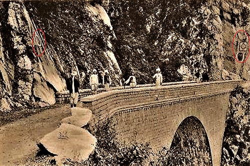
A photograph taken in 1915 of the Motto Bridge on the pipeline track going from Dunga Gali to Ayubia. The crests of the battalions that constructed the pipeline are encircled
Dunga Gali’s importance was its freshwater springs, which are the source of the River Haro. In 1885, the run-offs from natural springs and rain-water channels were networked to flow into large steel water storage tanks and construction commenced of the gravity-flow water supply scheme to Murree. It took seven years to lay a 10-inch pipeline coated with bitumen, and a meter under a 3-meter-wide track constructed on a relatively level alignment. The pipeline passed under the Ghora Dakka – Khanaspur Ridge through a narrow tunnel that was 80 meters long and two meters high. Named the Moto Tunnel, it was completed in 1891 and recently attractively renovated for tourists. After a drop in elevation of nearly a thousand meters from its starting point in Dunga Gali, the pipeline connected with the water tanks at Kashmir Point in Murree. The 30-km-long pipeline was laid through virgin forest most of the way, and much of the work was done by British troops. Testimony to this is the regimental crests that have been carved next to a bridge on the pipeline. During the 1950s, when Ghiasuddin Ahmed was Commissioner Rawalpindi Division, to meet the demand of the rising population in Murree, he had an additional pipeline laid from Dunga Gali.
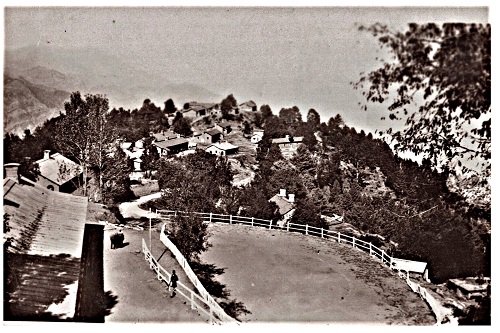
The remaining cantonments including those surrounding Murree were for detachments of infantry 300-500 strong. 14 km from Murree was Barian, nestled in a saddle and with a small but thriving bazaar that catered for a fairly large population in the adjacent valleys. 8 km further was Changla Gali at an altitude of 2,600 metres and was the highest hill station. A picturesquely situated dak bungalow constructed in 1875 commanded a striking view of the Murree ridgeline, the Margalla Hills overlooking the plain of Rawalpindi, and the southern portion of the Hazara District. From a vantage point, a fine view was obtained of Nanga Parbat. In 1888, Changla Cantonment became the summer venue of the Northern Command School of Musketry that spent its winters at Rawalpindi. At the bottom of the spur on which the small cantonment was constructed is a village called Chand Mari where the firing range was located. Ahead of Changla, there was a turnoff for Ghora Dakka and its adjoining cantonment of Khanspur, which were at an altitude of about 2,350 metres and located on a spur that projected steeply towards the Jhelum valley.
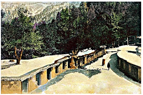
A winter scene of the bazaar of Barian, 6 km from Murree
After Independence, the Army could not maintain many of these cantonments, nor did they require them. Consequently, while they retained those around Murree for headquarters and schools of instructions, the accommodation was offered to officers of the defense services on long leases. In 1961 under an ordinance promulgated by the then government of West Pakistan, the Rawalpindi & Hazara Hill tract Improvement Trust was created and assigned the responsibility to develop the abandoned cantonments of Ghora Dakka / Khanspur, Changla Gali and Khaira Gali into hill resorts. The area comprising thes-e three townships was named Ayubia after Field Marshal Ayub Khan, the President of Pakistan. Gradually all the buildings were auctioned off, but some of the old structures in Khanspur along the road are still intact and well-spaced out – single-storey barracks for troops and double-storey sets of four suites for the officers. Bara Gali is the summer camp for students from Peshawar University, and is the most unspoiled of all the cantonments.
Many of the old structures within the cantonment areas built by the army have been retained but renovated. However, in places, modern concrete and glass buildings have been erected that look incongruous with the surroundings.