For a valley shaped like a bowl, Quetta certainly holds little water. So little, in fact, that those who have been watching it dry up believe that it will become a desert in a decade.
Dry conditions have persisted since 1997. The good rains that came in November and October come no more, according to Tahir Khan Dost at the meteorological department. There is almost no rainfall in December now. Last year, this winter month Quetta got only 0.01mm.
These trends seem to point to climate change but few studies have confirmed what many suspect. What is certain, however, and is clear to see, is that the city’s desperate tubewell boring is to blame. The more they have extracted water from the earth, the lower the groundwater table has dropped.
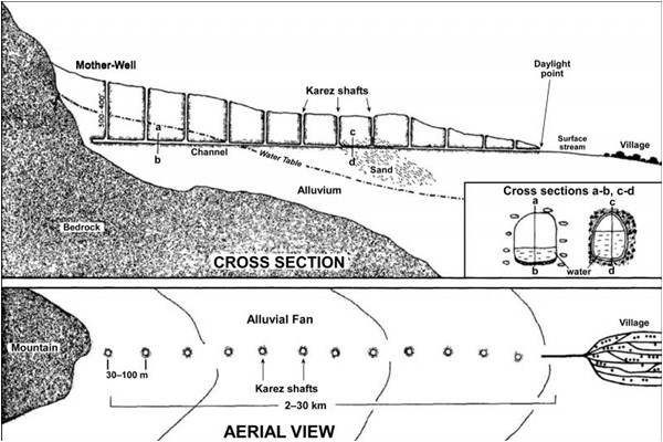
Karez Structure
Pishin's 25-year-old Syed Rehmat Ali has been living in Quetta since 2004 but says he has moved house six times-all in search of better water supplies
“The people of Quetta have consumed the water of the next generation,” says Dr Din Muhammad Kakar of Balochistan University’s department of Geology. According to his research, there are a stunning 20 tube wells in every square kilometer of the city. “We have drilled across the city and we don’t have any way to recharge groundwater,” he adds, referring to the process in which you put back what you have taken out. Rain usually does this, but there has been none of that.
“It is nothing short of suicide,” he adds. “We drill to get to water, the table drops, and we have to drill deeper. Due to hydrostatic pressure, when you drill water out, it is like taking air from a balloon.”
Researchers have found that the groundwater levels have been dropping for the last three decades. “[The] Water and Sanitation Authority of Quetta (WASA) is monitoring groundwater levels since 1989 and in some parts of the valley water decline up to 24 meters in 30 years is reported,” says a paper published by Shuhab Khan from the Department of Earth and Atmospheric Sciences, University of Houston.
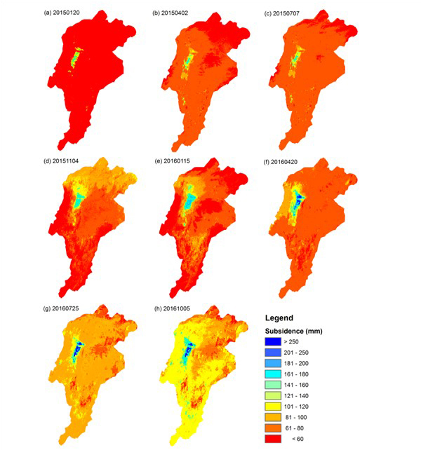
This map shows Quetta's land subsiding. It starts red with less than 60mm and eventually exceeds 250mm
Under Quetta valley are two aquifers. The top most layer which forms the valley floor is the unconfined alluvial aquifer made up of a mixture of gravel, sand and clay. It is at a depth of between 200m to 1,000m. The second aquifer, which extends from 200m to 1,500m is a confined aquifer and is composed of limestone formation. The crisis has prompted people to drill deep to extract what they call “fossil water” after boring through hard rock sometimes as deep as 300m.
One of the odd effects this water shortage has had is on the real estate market. Pishin’s 25-year-old Syed Rehmat Ali has been living in Quetta since 2004 but says he has moved house six times—all in search of better water supplies. “We are four brothers who live with our family,” he explains. “First we used to live at Shahwaksha Road, then Kasi Road, Gillani Road, Barori Road, Faqeer Muhammad Road. And now we are living at Mecongi road. We still need to order water tankers.”
They kept trying to move to neighbourhoods where the water tanker rates were lower but over the years even these prices have gone up steadily. A tanker used to cost Rs500 but is now Rs2,000. “I don’t know when I’ll have to move again over the water scarcity,” he says.
The other effect of Quetta's tube wells and lowering water table has been land subsidence, which in simple words means the ground is sinking. It is estimated to be 10cm a year
Private water tanker owner Badshah Khan estimates that more than 200 private tankers sell water in Quetta after pumping it from the ground. They each transport 11,000 gallons and one tanker does 10 rounds. They charge Rs1,500 to Rs2,500. “It is Rs3 million a day business.”
Real estate agents and residents say the driest neighbourhoods are Stewart Road, Jan Muhammad Road, Patel Bagh, Kucha Sher Muhammad Road, Gillani Road, Sariab Road, Barori Road, Shahbaz Town, Faqeer Muhammad Road, Toghi Road, Jinnah Road and Liaquat Bazaar.
“There is no area where there is not a water issue,” says Zahir Shah who has been working as a real estate agent for a decade. “People who reach out to us to buy or rent do it mostly because of the water problems. People keep moving to different areas but if this continues, they will have to migrate to another city.”
The World Bank says that the “overexploitation of the confined aquifer by agricultural users around the city has already led to a number of doomsday projections, predicting that in a foreseeable future even the supply from deep fossil groundwater to the capital of Balochistan province will dry up”.
Sink or swim
The other effect of Quetta’s tube wells and lowering water table has been land subsidence, which in simple words means the ground is sinking. It is estimated to be 10cm a year, as researchers say in a paper titled ‘Land subsidence and declining water resources in Quetta Valley, Pakistan’ that was published in the journal Environmental Earth Sciences in 2013. Three researchers, Abdul S. Khan, Shuhab D. Khan and Din M. Kakar used global positioning system (GPS) data from two places from mid-2006 to the beginning of 2009 when this rate showed up. Tubewell drilling also leads to cracks in the built infrastructure.
An alarming map of the land subsidence was prepared by researchers in Korea. It shows data from 2014 onwards. It starts out red with the land subsiding or sinking less than 60mm. By the end of the map, blue shows up where the land has sunk over 250mm. Researchers say that the first time land subsidence was noticed was in 2011 when 10m deep cracks appeared on an 8km long and 2km wide swath which damaged houses, roads and a hospital.
History
Quetta came into being in 1878 but was almost destroyed by an earthquake in 1935. After this the British started to build in 1942. At that point it was a city of 50,000 people which had room for only 10,000. “All this has rapidly changed in 40 to 50 years,” says researcher Dr. Irfan Baig.
Historically the city relied on wells and water from springs. But the more people came to Quetta, the harder it was to supply water. The population rose from 260,000 in 1975 to 1.2 million in 2010, mainly due to the arrival of refugees from neighbouring Afghanistan. People from the surrounding countryside also kept moving to the city in search of jobs and better schools for their children.
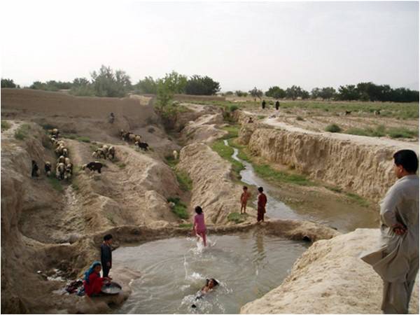
Up until the 1970s, Quetta used the karez system to irrigate its farmland. Karezes are just tunnels that emerge after intersecting with the groundwater table. Dr Daanish Mustafa, a Reader at the Department of Geography, King’s College London, has written about this system. The first well where the water is tapped for a karez is called the mother well. You are not allowed to dig new wells near it or you can threaten the quality and quantity of the groundwater. Water can only be used once it emerges from the daylight point. But as tube wells were dug and the water table dropped, the karezes have gone dry.
There is no law in Balochistan to regulate the use of water from tube wells or surface wells within the vicinity of karezes. In some areas there was a riwaj that no well should be allowed to dug close to the karez mother well (250 yards in case of soft land and 500 yards for stoney land).
As the water table fell in the 1990s, it became harder for farmers to make a living. Agriculture suffered. To make matters worse, there was a drought in 2003-04. The Balochistan Irrigation and Power Department found that 97 million cubic meters were being extracted annually. But only 62 percent of this was being recharged. Even Hanna lake, located 10km from Quetta and created by the British in 1894 to save rain water, dried up by 2004.
Infrastructure
Officially the city needs 49 mgd (million gallon per day) but has only 39mgd. “They can supply water somewhere between 15 mins to an hour,” says officiating WASA DG Imran Durrani. And that too depends on whether there is water in the 417 official tube wells.
Javed Ahmad, the chief engineer with the Public Health Engineering department, says these official tube wells provide 30mgd a day. But no one knows how many illegal ones there are. The WASA coordination cell has a list of 380 illegal ones and says it has sealed 127. According to Balochistan Groundwater Ordinance 1978, the deputy commissioner has the authority to act against illegal tube wells and water connections. But Quetta Mayor Kaleem Ullah puts the number of tube wells even higher at 3,600 and says half of them are illegal. Researchers estimate that there are around 11,000 pumping wells. In 2008, the government restricted new electricity connections for agricultural tube wells.
The DG’s frustration is palpable. “There are a lot of development projects going on in the city but before launching them they don’t acquire any sort of certification from Wasa,” he says. No one checks whether there is even enough water for these projects. “We don’t have an obligation to the whole country.”
Only 9,000 people out of Wasa’s 100,000 customers pay their bills which range from a pitiful 125 to 250 rupees, rates set in 1989. “The thella wallah here can buy a mobile phone credit balance of Rs500 but nobody can afford to pay their water bill,” says the DG. “The response from the public is zero. In Pakistan there is a concept that water is free. People pay three thousand times more for it around the world.”
Solutions
There is alarm. IUCN Balochistan representative Naseeb Ullah says at least they have been working since 1996 on water conservation. They know that the fossil water can end any time. Add to this the problem that drinking groundwater samples from Quetta valley have high concentrations of nitrate, sulfate, arsenic, selenium, chromium and nickel.
One solution is a proposed Maangi Dam to be constructed near Maangi village on the Khost River about 76km from Quetta. According to Nawab Muhammad Ayaz Jogezai, the minister Public Health Engineering, plans for the dam have existed since 1961 but the political system didn’t allow it to progress. “The funds for this project, because of our mistakes, have lapsed from the federal government,” he says. “I wanted to work on it and if our cabinet meeting had supported it, Maangi dam would have been functioning now.”
A second solution is to bring Quetta water from the Pat feeder. Jogezai says this project has been given to CPEC. “They are working on it. If we have the will, then we can be free from all these problems,” he added.
Dr Kakar is, however, sceptical about this solution. “To bring water from the Pat feeder will cost a fortune,” he says. Quetta is 323km from it. The water comes from Naseerabad to Sibi, Bolan and then Kohalpur which is 6,050 feet above sea level. Quetta is 5,050. He is instead in favour of building a controlled system, putting meters in every home, stopping agriculture and controlling the city’s population. A tall order for a sinking city.