I have a collection of images of tablets, signposts and way markers that provides a varied and interesting perspective to the history of the Raj.
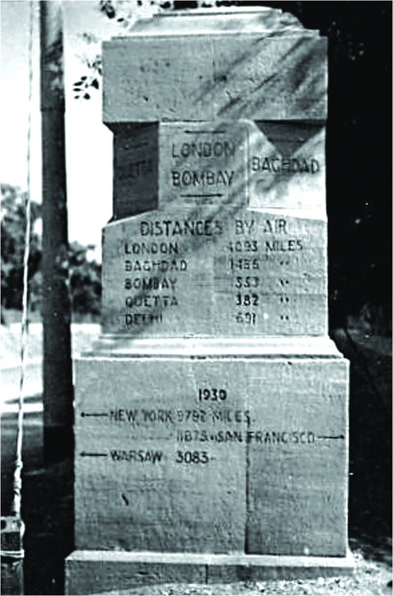
Most cantonments had way markers constructed in stone, indicating distances to various cities of the world. I have already mentioned about a way marker in Malir Cantonment in a previous article that provided the distances in miles to Baghdad (1,465) and London (6,093). The distances to New York (9,782), San Francisco via the Pacific route (11,875) and Warsaw (3,083) were probably added during the Second World War when the cantonment became a major US base to support the China-Burma-India (CBI) Theatre of the war, and also accommodated Polish refugees.
A way marker that has been preserved on the Rawalpindi Mall indicates distances (now converted into kilometres) to various cities to the north-west along and astride the Grand Trunk Road and also to destinations like the valleys of Abbottabad, Kaghan and Kashmir. However, one that I remember from my childhood at the nearby Chaklala Garrison, has sadly been demolished. Fortunately, a way marker with very interesting inscriptions has been preserved at Sialkot Cantonment. This Cantonment was established in 1852 and by the 1920s it was fairly large - with a length of 4km and a width of 2km. During this period, the garrison consisted of the 2nd (Sialkot) Cavalry Brigade, an infantry brigade of one British and two native battalions, a battery of horse artillery, engineers and transport units. The inscription on the top of the way marker is a quote from the Bible: “And a highway shall be there and the wayfaring men though fools shall not err therein.” The highway refers to the path leading to the Almighty and warns that it is not for sinners to traverse. The inscription on the left, above the distances to Delhi, Lahore, Peshawar, etc. states, “Yonder lie the scorching plains whence dust riseth like smoke from a furnace.” On the right are the distances to Ramban, Banihal and onwards to the beautiful Valley of Kashmir. The inscription above these reads, “The land wither ye go is a fair land of hills and green valleys and clear running water.”
A stone marker erected in Malir on which were inscribed the distances to cities in India and Europe. It also shows New York at 9,782 miles from Malir and San Francisco at 11,875 miles
The way marker at Tanai on the road from Tank to Razmak was erected during the hard fought Waziristan Campaign of 1936-39. Wazirs, Mahsuds, Bettanis and even Afghans from across the border rallied to the call for insurrection by Mirzali Khan, more commonly known as the Faqir of Ipi. They were well armed, with captured mountain guns and modern rifles mostly smuggled through the Persian Gulf route. Apart from many brigades of infantry and batteries of mountain artillery that were required to subdue the revolt, the British had to also employ two companies of tanks and six aircraft squadrons. Towards the east the way marker points towards Jandola and further to Tank, which was one of the bases for the campaign. The other base was at Bannu. To the north it points towards Wana and Razmak, which were established as permanent garrisons after an earlier campaign in 1919–20. The British strongly associated Razmak with the romance of the Frontier and because of its weather and beautiful surroundings called it Little London. Towards the south the way marker points towards Fort Sandeman which was constructed in 1890 and named after Robert Sandeman, who was the agent to the governor general of Balochistan. Quetta was 284 miles away, and with a sense of nostalgia, the distance to London (6,180 miles) had also been recorded.
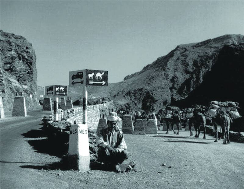
From Bannu the road led to Kohat and onwards to Peshawar through the narrow confines of the Kohat Pass, locally known as Darra Adam Khel (the pass of the Adam Khel Afridis). Prior to Independence, caravans of Powindas (a large nomad tribe) seasonally migrated from and to the Afghan Plateau. To ensure that their large caravans of camels and donkeys laden with goods for trading did not block motor traffic through the pass, somewhat unusual sign posts were erected to deflect the caravans towards tracks constructed for them. The picture that I have was taken sometime around the Second World War and shows the tank obstacles on the road that were constructed against a possible Soviet invasion that was deemed credible after the Soviet-German Treaty (also known as the Molotov–Ribbentrop Pact) in 1939. Tank obstacles called Dragon Teeth still exist in the narrowest confines of the Khyber Pass around Ali Masjid.
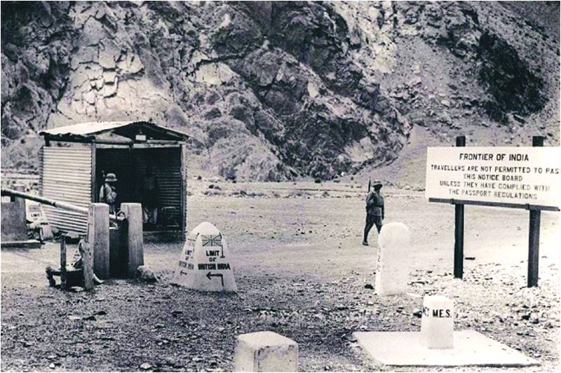
Sign posts and boundary pillar at the border crossing at Torkham on the Western end of the Khyber Pass. The Afghan soldiers may be seen wearing German steel helmets (Stahlhelme)
The British strongly associated Razmak with the romance of the Frontier and because of its weather and beautiful surroundings called it Little London
The most strategic and famous pass in undivided India was the Khyber Pass which led into Afghanistan. Unlike the present, the border crossing at Torkham on the western end of the pass was a simple affair with just a barrier and guard posts. A boundary pillar marked the limit of British India and a notice board warned travellers to comply with passport regulations before they crossed. The Afghans guarding the border crossing in the photograph look like Germans soldiers in their unmistakable helmets. In fact, after the Second World War, the Afghan Army was equipped with discarded German equipment, including small arms. Even till the 1990s, an interested buyer at the arms market at Darra Adam Khel could purchase a range of German small arms including MP38 and MP40 submachine guns, 8mm Gewehr Rifles, 7.63mm Mauser and 9mm Luger Pistols.
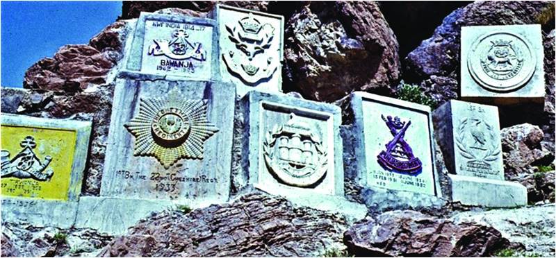
British battalions serving in the garrisons in the Northwest Frontier had a tradition of carving their badges on rock faces. While driving to Swat in the 1960s, I remember a number of them at the top of the Malakand Pass, but they were destroyed when the road was expanded. Fortunately, they are still preserved at some locations including the small hill station of Cherat and within the Khyber Pass. Closer towards Landi Kotal there is a group of around 15 badges which includes the Middlesex Regiment (1925), Gordon Highlanders (1931-32), 1st Battalion 22nd Cheshire Regiment (1933), 5th Battalion Borders Regiment (1933-34), the Dorsetshire Regiment (1935-37) and the 1st Battalion Queen’s Royal Regiment (1941-42). Some of the Indian battalions also carved their badges – 4/12th Frontier Force Rifles (Charwinjah) (1937-39), 1st Battalion Bahawalpur Regiment and one from the Punjab Regiment. The tradition continued after Independence.
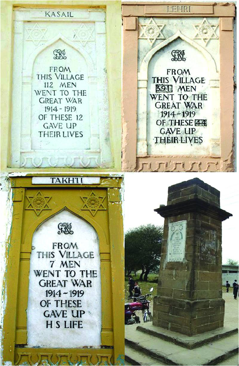
Over 70 memorial tablets were erected in villages in Punjab and KP during the First World War
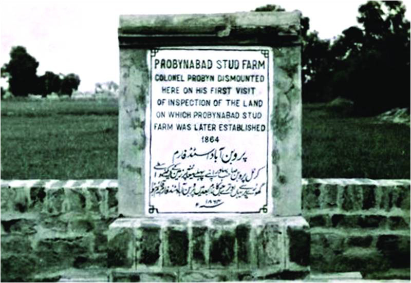
A plaque commemorating the establishmet of the Stud Farm at Probynabad near Okara in 1864
Less well known than the carved regiment badges in the Frontier but spread over a much greater area are memorials erected after the First World War in over 70 villages in Punjab, KP and elsewhere in India. Fifty-one percent of the 1.5 million who were mobilized in India during the Great War were Muslims largely from northern Punjab and NWFP (now KPK). The 25 tablets that have been found so far in the Punjab and 15 in KPK, conform to the areas of the castes and clans that were largely recruited into the British Indian Army. It covers a large swathe of the Potohar Plateau from the River Indus in the west extending east to the foothills of Kashmir and extending into the settled districts of KP. The tablets are of one design and erected by the Public Works Department. Many are set into a pillar 10 feet high with a large base. However, there seems to have been no central policy on where the pillars were to be located – which certainly led to their subsequently neglect. Those close to schools or post offices survived better than others. Fortunately, some were moved to more secure locations at a later period like a rest house or the office of the Union Council. The Majmat Dawud (Star of David in Arabic) on the corners of the tablet raises eyebrows. The symbol actually goes back to Egyptian times, representing Eternity and became a Jewish symbol much later.
Finally, one lone tablet that stands in a Military Farm near Okara deserves a mention because it is directly linked to the system of the irregular Silladar Regiments that prevailed in the British Indian Cavalry after the revolt of 1857. Their troopers were called Silladars (a Persian word meaning “bearer of arms”), who were issued weapon and ammunition but had to arrange for their horse, stabling attendant, forage, camp equipment and uniform for which they were entitled to a higher pay than their equivalent in the regular regiments. The system was modified in second half of the 19th century and regiments started providing recruits with a horse, equipment and uniforms for their value in money.
An unusual sign post in the Kohat Pass, erected to deflect the large and heavily laden Powinda caravans towards a track constructed for them
Spread over a much greater area are memorials erected after the First World War in over 70 villages in Punjab, KP and elsewhere in India. 51% of the 1.5 million mobilized in India during the Great War were Muslims
During the Second China War in 1860, the 11th King Edward’s Own Lancers (Probyn’s Horse), a Silladar cavalry regiment, established a China Fund subscribed to by the men. The sale of the loot was added to this money. On its return, Colonel Dighton Probyn, the commanding officer, used the fund to establish a stud farm and personally selected 1,200 acres near Okara. The first Arab stallion at the stud was Probyn’s own charger, Clear-the-Line, and the farm was subsequently named Probynabad. This was replicated by many other Silladar regiments on a lesser scale to rear mounts for the unit and also sell them to the army, which generated a good income. Probynabad enjoyed a long excellence in mounts and till the cavalry was mechanized, it reared over 2,000 horses. After Independence the land was taken over by the Pakistan Army.