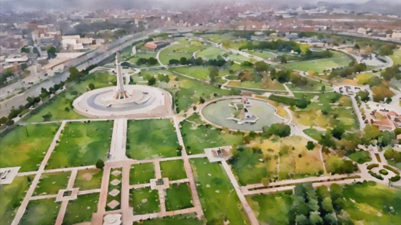
The oval-shaped vast area that is surrounded by part of the Circular Road in the east, the Buddha Ravi (now extinct) in its west and the Mosque-Fort complex in its south is popularly known as Minto Park. It is a large garden spread over nearly 125 acres, enclosed in a 3.08 km long boundary. The green grounds have transformed from a wild area across the River Ravi in the Mughal era to a parade ground during the Sikh rule to a general utility ground under the British, the setting for the adoption of the Pakistan Resolution during the freedom struggle, a favoured political public gathering since independence and, finally, to a recreational park with Minar-e-Pakistan as its central element. After independence, it was named Iqbal Park and, since 2017, renamed as Greater Iqbal Park to reflect its extensive development.
As for names, the old name of the park refers to Lord Minto, the Governor-General of India during the Napoleonic Wars from 1807 to 1813. Iqbal, of course, is Pakistan’s national poet and one of the original proponents of a separate homeland for Muslims in the subcontinent. This author is of the view that Sir Syed being the first Muslim leader to envisage a separate Muslim homeland in India, naming it after him would have been a better reflection of history. However, our religious lobbies have disfavoured Sir Syed and have adopted Iqbal as a true Muslim leader, and one can only defy the will of cult-like Mullahs at one’s own peril.
Having been silent witnesses to the fleeting nature of power, the sprawling grounds are transcendental in terms of their message.
Tracing the origin of this ground, it is known that as long as the Ravi flowed along the northern wall of the Fort till the middle of the 17th century, the area on the right river bank comprising this Park was the river’s extended sandy bed; dry in winters, flooded in summers and randomly covered in vegetation. The changing course of the Ravi will be covered in a separate piece as part of this series, but it has been recorded by Manucci (in Storio do Mogor) and Dr Bernier (in Travels in the Mughal Empire) that by March-April 1665, the Fort was no longer on the river bank, as the Ravi had shifted north by about five kilometres; to what should approximately be its current course. Only a secondary channel remained, later known as Buddha Ravi, which till late flowed from a little ahead of Badami Bagh railway station along the western side of Minar-e-Pakistan Park to cross Ravi Road, re-joining the main river a kilometre-and-a-half east of Bhaati Gate.
In the mid-18th century, Ahmad Shah Abdali occupied and plundered Lahore twice, and it is known that in both cases, instead of approaching the Fort directly from the north, he attacked the city from the east (from the Shalimar Gardens) and southeast (through what is today the airport/Askari X), indicating that the grounds of the Park at that time were still not conducive for cavalry movements.
During Ranjit Singh’s rule in the early 19th century, however, this ground was regularly used for military manoeuvres to train his infantry, cavalry and artillery regiments; a use that continued during the initial British rule. It was therefore called the parade ground; a name that was used by the early British writers to describe the area. A map of 1867, that depicts the Lahore-Amritsar railway line terminating at the railway station, shows a vacant ground at the site of Minto Park with its current boundaries of Buddha Ravi on the west and a road/track on the east. It also shows a road or a track running north through the middle of the ground from the Fort towards north. The area further east from the road up to the road track, where the railway line to Shahdara would be laid a few years later, has a number of gardens named after the then Sikh dignitaries.
The boundary of the park, from the mid-19th century, is roughly circular. The alignment of the Buddha Ravi channel continued to define the western and northern boundary of Minto Park well into 1980s. On the eastern side of this ground, the Lahore-Amritsar railway line was extended from Lahore Railway Station towards Rawalpindi in 1870s, prompting some economic activity on the western side of the railway line towards the then Sikh gardens. However, the park ground was preserved. The first road bridge over Ravi was constructed in 1914, adjacent and downstream to the railway bridge built earlier in 1871-76. The road bridge was connected to the GT Road by a road built over the existing animal-driven carriage track that ran from about outside the Masti Gate to the river bank on the site of a ferry that plied boats between Lahore and Shahdara. This road, now a crowded dual carriageway hosting many bus and truck stands, continues to mark the eastern boundary of the Minto Park, whereas the Fort-Mosque complex defines the southern boundary. It can therefore be concluded that the outline of these grounds emerged during the Sikh period and were secured during the British period. To the credit of all the federal and Punjab governments since independence, these boundaries have been strictly preserved.
Instead of approaching the Fort directly from the north, Ahmad Shah Abdali attacked the city from the east (the Shalimar Gardens) and southeast (what is today the airport/Askari X), indicating that the grounds of the Park at that time were still not conducive for cavalry movements
Col Goulding informs us (Old Lahore, pp 14) that a portion of the parade ground was designated as Minto Park by the British. He also indicates that the whole area as defined above was initially used for military and sports activities, but later, when the two ends of the Mall Road became the centres of the British civil and military establishment, it was utilised for various outdoor activities, including the creation of a park for the general public. However, some military presence continued well into the first decade of the 20th century; as a map of that era shows the western half of the Minto Park, along the Buddha Ravi, as the Encamping Ground. Interestingly, this map shows the boat bridge at the current Lahore-Shahdara road bridge, but does not depict the old road bridge next to the railway bridge over Ravi, meaning thereby that it belongs to the time before introduction of motorised transport.
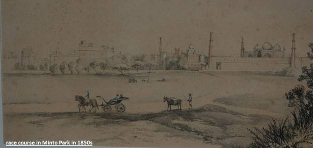
In the early British times, before the development of Mian Mir cantonment, when the British wanted to have a race course in Lahore, they found the vast ground suitable for this purpose. A part of it was converted for horse racing – with allied arrangements for horses, trainers, spectators and punters. That was in the early 1850s, around the time when the plans for Mian Mir Cantonment and the Mall Road were being finalised. Later, with the shifting of the troops from around Chauburji and Anarkali to the new cantonment, the race course ground too was relocated to its present site.
A portion of the Minto Park also served as the polo ground during the early British times. Goulding (ibid) distinctly remembered the first match being played there in early 1870s with the young Nawabs of Bahawalpur and Mamdot in the teams. The polo ground, too, was later relocated to the Race Course Ground on the Mall. A part of the ground served as cricket ground as well before the centre of the game shifted to Gymkhana and Lawrence Gardens on the Mall Road, where it stayed till the development of the Qaddafi Stadium on the junction of Ferozepur Road and Gulberg Main Boulevard. However, many amateur cricket lovers – like this author himself in his childhood – continued to play cricket in Minto Park in the afternoons and the weekends. Here credit must be given to the British planners that they built large gardens around the Mall and the canal including the Governor House grounds, Aitchison College grounds, Mayo Gardens, Zaman Park, Lawrence Gardens and Race Course grounds. These green areas are the breathing lungs for the city of Lahore. Sadly, many of the trees planted by them along the Mall and the Canal have been cut after independence for urban development, without putting in the effort to have them relocated or planting replacement trees of a similar type. Here credit must be given to CDA Islamabad, who routinely relocates the trees that come in the way of urban development.
Till early this century, as this author often saw in his youth, the central part of the Minto Park used to be thronged with kite-fliers on weekends. It was called, and Google Maps still depicts it as such, Guddi (Kite) Ground. When kite flying was banned in the city, it was unsuccessfully proposed by many enthusiasts that the sport should be allowed in this Guddi Ground. Nearby, there was also a ring (akhara) for the wrestlers practising grappling (pehlwani).
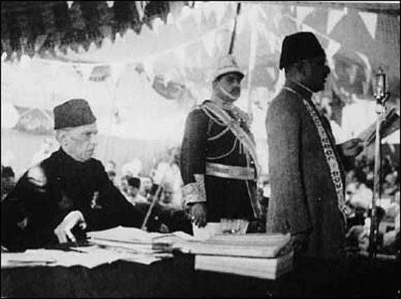
On 22-24 March 1940, the grounds gained an everlasting importance when the Muslim League held its public meeting here to present the Pakistan Resolution demanding the creation of a separate homeland for Muslims of India. The AI-generated information by Google on the subject informs that it was Quaid himself who chose the venue because of its historical importance, as the fort represented the occasional capital of the Mughal empire. It was expected that 20 to 30,000 would attend the session, however, the actual attendance was in close proximity of 100,000. In 1960, the then military president Ayub Khan, perhaps as a populist move, decided to build a memorial for the occasion. Resultantly, a 62-meter high tower on an 8-meter high base, designed as a flower and two crescents, was completed in 1968. This author, as a resident in Paniwala Talab, has witnessed the construction of the monument from start to finish, and has climbed it many times while visiting the park in early 1970s with his cousins and friends. Later, the mortal remains of Hafiz Jallandhari, creator of Pakistan’s national anthem and Azad Kashmir’s anthem, were reinterned in the same Park. The museum of national history is also established in its north western corner.
In 2017, a great initiative was taken by the then government to restructure the whole ground and remodel it as a recreational historical park. Now, the entire erstwhile parade ground has been consolidated as a thematic park befitting its importance and named Greater Iqbal Park. It attracts a large number of people for recreation. In 2022, this author visited the Park with his children and grandchildren, who had never before been to the place before. It was delightful walking around the monument and taking ride in the decorated horse carriages. It was a trip they would remember, and one that rekindled author’s old memories of the place.
From parade ground to Minto Park to Iqbal Park and finally to Greater Iqbal Park, the historic grounds north of the complex that houses Badshahi Mosque, Mughal Fort, Hazuri Bagh and Baradari, Ranjit Singh’s Samadhi and Shaheedi Gurdwara is a national treasure and a living museum. It is, perhaps, more legendary than any other park in the world. A greater visionary nation would have created a tourist ride from this location to the other historic park to the west in Shahdara enclosing tombs of Jahangir, Noor Jahan and Asif Khan and, through the Shahi Guzurgah to Wazir Khan Mosque, Shahi Hamam, Delhi Gate and on to Shalimar gardens in the east. That would have been a popular tourist site attracting millions of visitors each year.